
Linville Historic District
History
Linville, in Avery County, is one of the highest towns in the East, situated more than 3,600 feet above sea level on a plateau near the Blue Ridge Mountains. Approaching from any direction along twisting mountain roads, one is greeted by a quiet community composed mainly of private residences nestled among rhododendrons and azaleas in parklike sites punctuated by tall pine trees.
Linville Historic District is a historic school campus and national historic district located at Linville, Avery County, North Carolina. It encompasses 96 contributing buildings and 4 contributing structures in the historic core of Linville. The buildings date between about 1892 and 1940 and include shingle-or chestnut bark-covered resort buildings and the second generation of houses flanking the first and eighteenth fairways of the golf course. Notable buildings include the Hemlock Cottage, Dormiecroft, “Honeymoon” Cottage, Presbyterian Church, The Studio, the VanLandingham House, and All Saints Episcopal Church.
The most striking feature common to most of these houses is their sheathing of shingles cut from chestnut bark, a feature that enhances their relation to the natural setting. Although there are a few hundred people who are permanent, year-round residents of the town, Linville is usually referred to as a resort as its origin and development have been almost completely dictated by those property owners who envisioned the town as an isolated vacation retreat.
The town as a whole radiates from the intersection of N. C. 181, N. C. 105, and U. S. 221, with most of the development occurring to the south and the east where most of the resort houses are located. To the northeast of Linville is Grandfather Mountain, to the southeast is Grandmother Mountain, and in the western part of the town is Pixie Mountain. The resort area is located along a north-south axis that runs between Pixie Mountain and Grandmother Mountain, with structures beginning in the west on the lower slopes of Pixie Mountain and extending to the east over Grandson Hill. As the north-south arm of N. C. 181 U. S. 221 (hereinafter referred to as Linville Avenue) runs close to the base of Pixie Mountain, most of the resort extends over the more level area to the east of Linville Avenue. The majority of the resort houses (excluding those built during the past fifteen years) are well-integrated with the landscape due to their distinctive facades of chestnut-bark shingles.
While typical shingle-style houses were built through the 1890s, a unique, completely localized shingle styJe emerged in Linville with the designs of Henry Bacon. Noted for his rnonument design, particularly that of the Lincoln Memorial, Bacon was introduced to Linville by his close friends from his home town of Wilmington, the MacRaes, the principal investors in Linville.
Linville Historic District
| Header | Data |
|---|---|
| NRHP ID | 79001659 |
| Date Added | Mar 07, 1979 |
| Property | 140 acres |
| Architect | Henry Bacon, Et. al. |
| Builder | Harry Stearns, Et. al. |
| Classification | District |
| Significance | 1888 – Present |
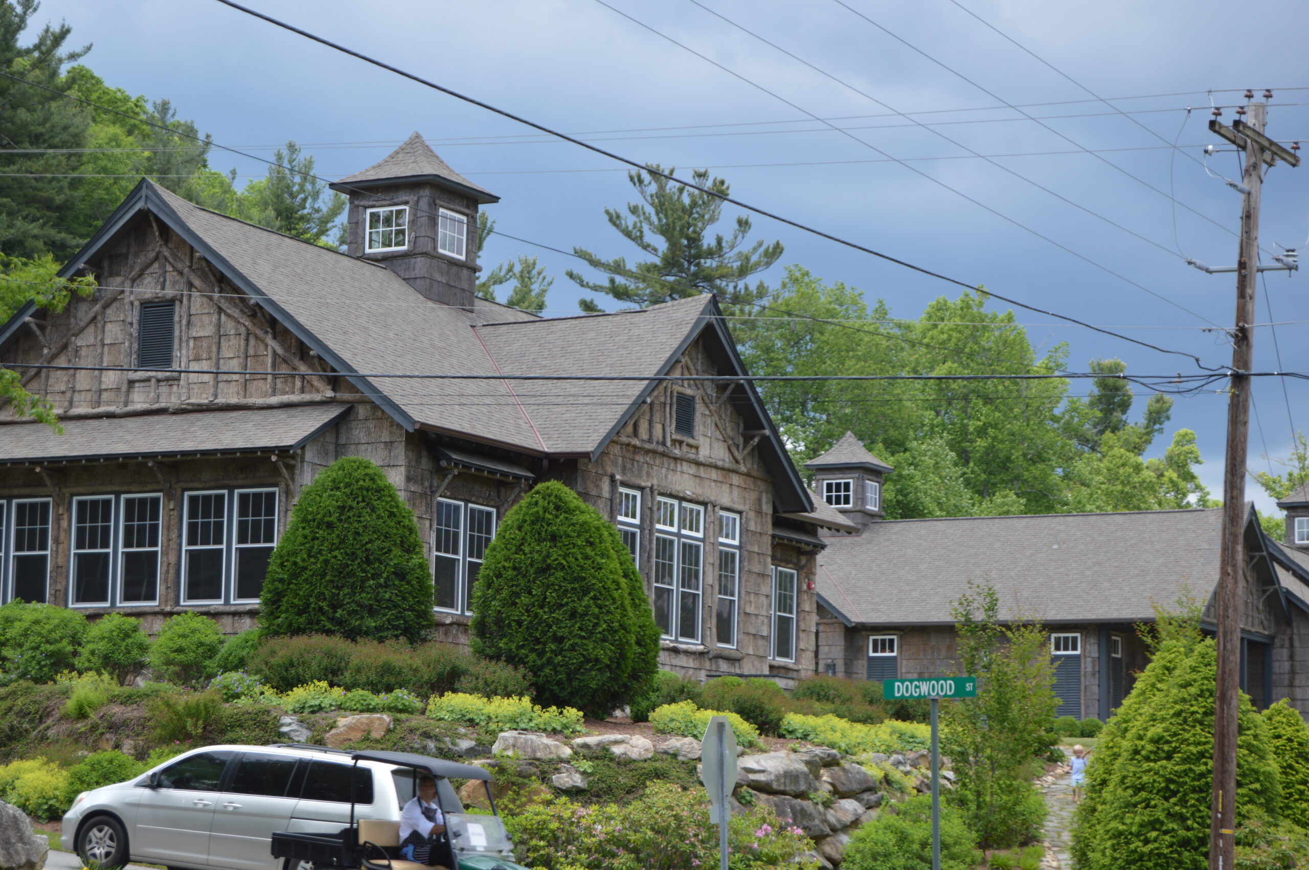
Bacon apparently was intrigued with the variety of wood natural to the area and with the great abundance of mature chestnut trees. During visits that spanned, approximately, the years 1895 to 1910, Bacon was prompted to make designs for a few buildings. All of these structures were covered in chestnut-bark shingles that set the style for all subsequent buildings in Linville, and much of the surrounding resort areas, until the chestnut trees were attacked by the blight of the late 1930s. Bacon’s houses are further distinguished by simple, symmetrical plans that are reflected in the facades, exposed beams of unstripped logs, lattice railings of logs, and wide, plank entrance doors.
In 1920, the ascendancy of Hugh MacRae’s son, Nelson, to the presidency of the Linville Improvement Company, signaled an extensive building campaign that would last, only slightly slowed by the Depression, until World War II. The development most significant in determining a general southerly direction of expansion was the new golf course laid out south of Dogwood Street. The original golf course began at the old Inn and extended north on either side of the present N. C. 181 until the area of the stables in the northeast quadrant of the highway intersection. Only by playing four holes twice could one play a complete round of eighteen holes on this course. The new course would offer a more enjoyable and more challenging game and thereby would attract more vacationers; at the same time, it would provide choice sites for these potential landowners.
Notable People
- Bacon, Henry
Geography & Location
Linville Historic District
Linville, NC 28646
Linville Historic District Gallery


